Introduction to Leveling:
Leveling is the procedure used to determine differences in elevation between points that are remote from each other. It refers to height measurements for representing the relative difference in height (altitude) between various points on the earth surface. Common leveling instruments include the spirit level, the dumpy level, the digital level, and the laser level.
In this practical session, we use traditional method of leveling where we need to be in touch on the ground, So, basic equipment like tripod auto level, staff, bubble staff, and measuring tape are used. The purpose of leveling is to establish new vertical control; Bench Mark (BM) and temporary bench mark (TBM). Leveling also is done for determining the height of discrete points and provide spot heights or contour on a plan.
BASIC DEFINITIONS:
Vertical line:
A line that follows the local direction of gravity as indicated by a plumb line.
Level line:
A line in a level surface therefore, a curved line.
Horizontal plane:
A plane perpendicular to the local direction of gravity. In plane surveying,
it is a plane perpendicular to the local vertical line.
Horizontal line:
A line in a horizontal plane. In plane surveying, it is a line perpendicular to
the local vertical.
Datum:
A datum is any reference surface to which the elevations of points are referred. The
most commonly used datum is that of mean sea level (MSL).
Elevation (Reduce Level):
An elevation is a vertical distance above or below a reference datum. In surveying,
the reference datum that is universally employed is mean sea level (MSL).
Bench Mark (B.M):
It is a station or a point whose elevation is known.
Back Sight (B.S):
It is the first reading taken on a point of known elevation.
Fore Sight (F.S):
It is the last reading taken before shifting the instrument. It is usually on the point whose elevation is to be determined.
Intermediate Sight (I.S):
All the readings taken between B.S and F.S.
Turning Point (T.P):
It is the point indicating the shifting of the station. At this point, F.S and B.S both are taken.
Height Of Instrument (H.I):
It is the elevation of the plane of collimation when instrument is correctly leveled. It is also called "height of plane of collimation."
Methods of leveling
Barometric leveling
Barometric leveling makes use of the phenomenon that difference in elevation between two points is proportional to the difference in atmospheric pressures at these points. A barometer, therefore, may be used and the readings observed at different points would yield a measure of the relative elevation of those points.
At a given point, the atmospheric pressure doesn’t remain constant in the course of the day, even in the course of an hour. The method is, therefore, relatively inaccurate and is little used in surveying work except on reconnaissance or exploratory survey.
Trigonometric Leveling (Indirect Leveling)
Trigonometric or Indirect leveling is the process of leveling in which the elevations of points are computed from the vertical angles and horizontal distances measured in the field, just as the length of any side in any triangle can be computed from proper trigonometric relations. In a modified form called stadia leveling, commonly used in mapping, both the difference in elevation and the horizontal distance between the points are directly computed from the measured vertical angles and staff readings.
Spirit Leveling (Direct Leveling)
It is that branch of leveling in which the vertical distances with respect to a horizontal line (perpendicular to the direction of gravity) may be used to determine the relative difference in elevation between two adjacent points. A horizontal plane of sight tangent to level surface at any point is readily established by means of a spirit level or a level vial. In spirit leveling, a spirit level and a sighting device (telescope) are combined and vertical distances are measured by observing on graduated rods placed on the points. The method is also known as direct leveling. It is the most precise method of determining elevations and the one most commonly used by engineers.

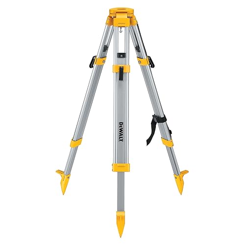
The tripod consists of three legs and a head where the level instrument is mounted. The tripod could be of aluminum or wood material. When leveling the level instrument, the tripod head must be set approximately level beforehand by adjusting the tripod legs.
These are generally a small circular bubble on an angle plate which is held against one corner of the staff to ensure that the staff is held in a vertical position. If the staff is not held vertical, the reading will be too large and may be significantly in error.

Reciprocal leveling
It is the method of levelling in which the difference in elevation between two points is accurately determined by two sets of observations, when it is not possible to set up the level midway between two points.Profile leveling
It is the operation in which the object is to determine the elevation of points at known distances apart along a given line so as to obtain accurate outline of the surface of the ground. This is also known is as longitudinal levelling. There are 2 ways to calculate reduce level in profile leveling.- Height of Instrument method
- Rise and Fall method
Equipment used in Profile leveling
Automatic level
A level is basically a telescope attached to an accurate leveling device, set upon a tripod so that it can rotate horizontally through 360°. The following figure shows the level and its components.Tripod
The tripod consists of three legs and a head where the level instrument is mounted. The tripod could be of aluminum or wood material. When leveling the level instrument, the tripod head must be set approximately level beforehand by adjusting the tripod legs.
Leveling staff
The leveling staff is a box section of aluminum or wood, which will extend to 3 or 5 m in height by telescoping, hinging or addition of sections. One face has a graduated scale attached for reading with the cross-hairs of the level telescope. |
| STAFF |
Staff bubbles
These are generally a small circular bubble on an angle plate which is held against one corner of the staff to ensure that the staff is held in a vertical position. If the staff is not held vertical, the reading will be too large and may be significantly in error.
No comments:
Post a Comment